Cincinnati’s first-ring suburbs face unique challenges. Changing demographics, economic stability, and issues regarding resources and security are common threads among these jurisdictions.
The ways the 49 Hamilton County cities, villages, townships, and municipal corporations not only adjust but thrive is the focus of this series, First Suburbs—Beyond Borders. The series explores the diversity and ingenuity of these longstanding suburban communities, highlighting issues that demand collective thought and action to galvanize their revitalization.
When Mary Miller and her husband retired, people said they were doing it backward. Eager to move closer to family, they moved out of the sunny clime of Arizona and into the fickle weather and urban hum of Norwood, Ohio.
With a grown daughter and a grandchild in Cincinnati, the Millers spent two weeks here touring more than 50 homes for sale. They wanted an urban neighborhood where you can walk to things, and where there was some diversity in age, income, and race.
They bought a 122-year-old house on Hopkins Street that needed a little work. When the contractor they hired was finished, he asked, “Why in the world would you want to move to Norwood?” That was her first experience with the all-too-common, popular perception of Norwood as a Rust Belt burg whose best days were behind it.
As Cincinnati's first-ring suburbs go, Norwood is fairly large. Nearly 20,000 residents live there. While its population has remained relatively stable for the last decade, it has fallen by nearly half since its heyday in the ‘50s and ‘60s.
The
closure of a General Motors assembly plant there in the late ‘80s, as well as other plant closings, dealt an economic blow to the town, but recent years have seen major developments. The Rookwood shopping centers have become regional shopping destinations, and the former U.S. Playing Card complex, which closed in 2008, has been redeveloped as
Factory 52, an entertainment district and residential neighborhood. Development around Xavier University, which sits on Norwood’s western border, has added another element of walkability.
It didn’t take Mary long to get busy trying to change the perception of Norwood, and she became one of the prime movers behind the creation of
Norwood Together, a community group that organizes, engages, and connects neighbors in civic projects.
Miller and like-minded neighbors eventually formed a 501c3 organization, and with help from the Cincinnati office of
Local Initiatives Support Corp. (LISC),
Interact for Health and other organizations, put together a plan to improve the quality of life in the city.
Norwood’s major thoroughfares of Montgomery Road running north-south, and the Norwood Lateral, running east and west, essentially divide up the city’s neighborhoods into four quadrants. One of the goals of Miller’s group was to figure out how to get from one neighborhood to another without a car, to encourage biking or walking to the newly developed
Wasson Way trail on the city’s southern border, and to easily access the Montgomery Road retail corridor and safely walk around there.
Those goals got a significant boost when the
Congress for New Urbanism, a Washington, D.C.-based nonprofit dedicated to improving the design of cities, towns, and neighborhoods, agreed to sponsor a “legacy project” in Norwood to coincide with the CNU’s annual gathering, which will take place in Cincinnati in mid-May.
The project came with the expertise of the global design and planning firm
Stantec, and its experts put together a plan to better connect the neighbors and the neighborhoods in a city that has been disconnected by the automobile-focused planning of the previous century.
“The theme is connecting neighbors, connecting neighborhoods, and connecting Norwood with the neighboring communities,” Miller says. “Building connectivity in our city.”
After meeting with residents and city officials and hearing their ideas, the Stantec design team created a plan that identifies four kinds of connections to enable easier travel around town.
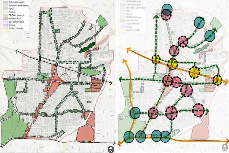
![]() The plan, left, shows key corridors (lined with trees), commercial areas (red), green spaces, and neighborhoods. At right are the opportunities identified for improvements, including corridors (green dotted lines) and intersections (pink)
The plan, left, shows key corridors (lined with trees), commercial areas (red), green spaces, and neighborhoods. At right are the opportunities identified for improvements, including corridors (green dotted lines) and intersections (pink)The experts identified seven corridors, thoroughfares that could be traveled by foot, bicycle, car, or bus to get from one neighborhood to another. They identified nine intersections that could be improved and made safer for pedestrians, and eight “gateways” that could connect residents to Wasson Way and the
CROWN multi-use trail that is under development.
In the 1900s, Norwood grew thanks to its to railroad connections. But now a rail line hinders access, so the planners suggested improving a little-used tunnel to permit walkers and bikers to safely cross under the railroad to connect with recently developed Factory 52 district on the city’s southeast side.
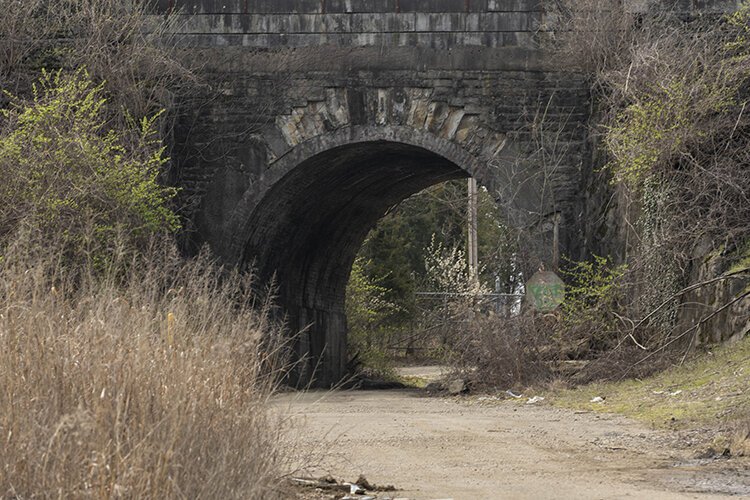
![]() The Harris Avenue tunnel could be a neighborhood connector in the plan.
The Harris Avenue tunnel could be a neighborhood connector in the plan.Cities like Norwood, many of them first-ring suburbs that came of age in the 19
th and early 20
th centuries, were built on a neighborhood scale, with sidewalks, walkable business districts, and dense residential streets. But the primacy of the car in the mid-20
th century meant roadways expanded, and strip centers with big parking lots were built. Now, Norwood and other small towns are rediscovering the strengths they were built on.
“The dynamics of pedestrian travel have changed, and that's something that communities such as ours have to really look at and make improvements,” says Norwood Mayor Victor Schneider.
“First ring suburbs across the country are facing the same issues, but they also have similar opportunities and assets that they can take advantage of to move forward,” says Robert Steuteville, editor of Public Square, the journal of the Congress for New Urbanism.
Implementing all or part of the plan will take time, energy and money. Having a detailed plan in place will help the city access public and private grants to realize some of the vision, Schneider says.
For Norwood Together’s Miller, the process has already paid off by engaging volunteers to commit to working together to improve a city that is ready to change its public perception.
Norwood will receive a full report from the planning and design team at the 32nd Congress for New Urbanism, which meets in Cincinnati at the Hilton Netherland Plaza from May 15-18. Other CNU Legacy Projects in 2024 were prepared for the Cincinnati neighborhood of Camp Washington, the city of Xenia, and Amelia, the unincorporated village in Clermont County.
The First Suburbs—Beyond Borders series is made possible with support from a coalition of stakeholders including the Murray & Agnes Seasongood Good Government Foundation - The Seasongood Foundation is devoted to the cause of good local government; Hamilton County Planning Partnership; plus First Suburbs Consortium of Southwest Ohio, an association of elected and appointed officials representing older suburban communities in Hamilton County, Ohio.